Cyclone Nargis
 All this artical are copied from Wikipedia
Cyclone Nargis (JTWC designation: 01B, also known asVery Severe Cyclonic Storm Nargis), was a strongtropical cyclone that caused the worst natural disaster in the recorded history of Burma (officially known as Myanmar).[7]The cyclone made landfall in the country on May 2, 2008, causing catastrophic destruction and at least 146,000 fatalities with thousands more people still missing.[8] However, although the Labutta Township alonewas reported to have 80,000 dead, with about 10,000 more deaths in Bogale; and many other deaths were found in other towns and areas, the Burmese government's official death toll is grossly underreported as they have simply stopped counting the dead to minimize political fallout. It is feared and quite possible that due to lack of relief efforts, a total of a million people already have or will die from this catastrophe.[9] Damage is estimated at over $10 billion (USD), which made it the most damaging cyclone ever recorded in this basin. [10]
Nargis is the deadliest named cyclone in the North Indian Ocean Basin, as well as the second deadliest named cyclone of all time, behind Typhoon Nina of 1975. Including unnamed storms like the 1970 Bhola cyclone, Nargis is the 8th deadliest cyclone of all time, but an uncertainty between the deaths caused by Nargis and those caused by other cyclones (like the 1991 Bangladesh cyclone), could put Nargis as 7th deadliest or higher, because the exact death toll is unknown; it is assumed 7th deadliest as of now. Nargis was the first tropical cyclone to strike the country since Cyclone Mala made landfall in 2006, which was slightly stronger, but had a significantly lower impact.
Relief efforts were slowed for political reasons as Burma's military rulers initially resisted aid. U.S. President George W. Bush said that an angry world should condemn the way Burma's military rulers are handling the aftermath of a catastrophic cyclone.[11] Burma's ruling party finally accepted aid a few days after India's request was accepted.[12] Furthermore hampering the relief effort was the unfortunate fact that only ten days after the cyclone nearby central China was hit by a massive earthquake, known as the Sichuan earthquake which measured 7.9 in magnitude and it alone has taken 69,136 lives[citation needed], and caused 86 billion dollars in damage (USD), making it the costliest disaster in Chinese history and third costliest disaster worldwide. Furthermore, some donated aids were found to be available in the country's black market, and Myanmar's junta warned on May 15th that legal action would be taken against people who trade or hoard international aid.
The cyclone name "Nargis" (نرگس, IPA: næɵr-ɡɵs), is an Urdu word meaning daffodil, which has its roots in the Persian Nargess (given name), which has the same meaning.[13] The first named storm of the2008 North Indian Ocean cyclone season, Nargis developed on April 27 in the central area of Bay of Bengal. Initially it tracked slowly northwestward and, encountering favorable conditions, it quickly strengthened. Dry air weakened the cyclone on April 29, though after beginning a steady eastward motion Nargis rapidly intensified to attain peak winds of at least 165 km/h (105 mph) on May 2 according to IMD observations; the JTWC assessed peak winds of 215 km/h (135 mph), making it a weak Category 4 cyclone on the SSHS. The cyclone moved ashore in the Ayeyarwady Division of Burma at peak intensity and, after passing near the major city of Yangon (Rangoon), the storm gradually weakened until dissipating near the border of Burma and Thailand.
Storm history
Western Bay of Bengal
In the last week of April 2008, an area of deep convection persisted near a low-level circulation in the Bay of Bengal about 1150 km (715 mi) east-southeast of Chennai, India.[14] With good outflow and low wind shear, the system slowly organized as its circulation consolidated.[15] At 0300 UTC on April 27, the India Meteorological Department (IMD) classified the system as a depression,[16] and nine hours later the system intensified into a deep depression.[17] At the same time, the Joint Typhoon Warning Center classified it as Tropical Cyclone 01B. With a ridge to its north, the system tracked slowly north-northwestward as banding features improved.[18][19] At 0000 UTC, 5:30 AM Indian Standard Time, on April 28, the IMD upgraded the system to Cyclonic Storm Nargis while it was located about 550 km (340 mi) east of Chennai, India.[20]
On April 28 Nargis became nearly stationary while located between ridges to its northwest and southeast. That day the JTWC upgraded the storm to cyclone status, the equivalent of a minimal hurricane on the Saffir-Simpson hurricane scale.[21] Around the same time, the IMD upgraded Nargis to a severe cyclonic storm.[22] The cyclone developed a concentric eye feature, which is an eyewall outside the inner dominant eyewall,[23] with warm waters aiding in further intensification.Early on April 29, the JTWC estimated Nargis reached winds of 160 km/h (100 mph),[25] and at the same time the IMD classified the system as a very severe cyclonic storm.[26] Initially, the cyclone was forecast to strikeBangladesh or southeastern India.[27][28] Subsequently, the cyclone became disorganized and weakened due to subsidence and drier air; as a result, deep convection near the center markedly decreased. At the same time, the storm began a motion to the northeast around the periphery of a ridge to its southeast.[29] The circulation remained strong despite the diminishing convection, though satellite intensity estimates using the Dvorak technique indicated the cyclone could have weakened to tropical storm status.[30] By late on April 29, convection had begun to rebuild,[31] though immediate restrengthening was prevented by increased wind shear.[32]

Satellite image of Nargis near landfall
On May 1, after turning nearly due eastward, Cyclone Nargis beganrapidly intensifying, due to greatly improved outflow in association with an approaching upper-level trough.[33] Strengthening continued as it developed a well-defined eye with a diameter of 19 km (12 mi), and early on May 2 the JTWC estimated the cyclone reached peak winds of 215 km/h (135 mph) as it approached the coast of Burma, making it a Category 4 storm.[34] At the same time, the IMD assessed Nargis as attaining peak winds of 165 km/h (105 mph).[35]Around 1200 UTC on May 2, Cyclone Nargis made landfall in theAyeyarwady Division of Burma at peak strength.[36] The storm gradually weakened as it procceded east over Burma, with its proximity to the Andaman Sea preventing rapid weakening. Its track turned to the northeast due to the approach of a mid-latitude trough to its northwest, passing just north of Yangon with winds of 130 km/h (80 mph).[37] Early on May 3 the IMD issued its final advisory on the storm.[38] It quickly weakened after turning to the northeast toward the rugged terrain near the Burma-Thailand border, and after deteriorating to minimal tropical storm status, the JTWC issued its last advisory on Nargis.[39]
Impact
In Sri Lanka the cyclone produced heavy rainfall which led to flooding and landslides across ten districts in the country. The districts of Ratnapura and Kegalle were the most affected, where more than 3,000 families were displaced. Thousands of houses were flooded, with 21 reported destroyed. The rainfall left 4,500 people homeless,[40] and more than 35,000 people were affected on the island.[41] Three people were reported injured on the island, with two others dead.[40]
The India Meteorological Department recommended that fishermen should not sail on the ocean during the passage of Nargis. Strong waves and gusty winds were expected along theTamil Nadu and Andhra Pradesh coastline in India.[20]Additionally, the influence of the cyclone lowered temperatures along the Indian coastline, which had been affected by a severe heat wave.[42]

Rainfall rate from cyclone Nargis over Western Bay of Bengal, as measured by the
TRMM
When the cyclone was originally expected to strike near Bangladesh, officials requested farmers to hurriedly finish harvesting the rice crop. At the time, the country was experiencing severe food shortages from Cyclone Sidr in the previous year and flooding earlier in the year, and a direct strike from Nargis would have resulted in destroyed crops due to strong winds.[43]
Burma (Myanmar)
The United Nations estimated that 1.50 million people were "severely affected" by this cyclone.[44] Estimates of the people still missing are 55,917, with 77,738 confirmed dead.[45]Some non-governmental organizations estimating that the final toll will be over 100,000.[46]At least 10,000 people have been reported to have perished in the delta town of Bogalealone.[47]
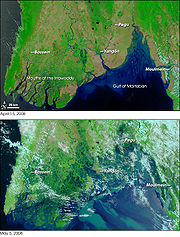
Satellite photography of the
Irrawaddy Delta before (top) and after (bottom) Nargis hit the area.

Topographic map of the region of Burma affected by Cyclone Nargis. The low-lying
Irrawaddy Delta was the hardest hit region.
Nargis was the deadliest tropical cyclone worldwide since the1970 Bhola cyclone, which killed nearly 500,000 people. One aid worker has claimed that the death toll from the cyclone and its aftermath may reach 300,000; if this is correct, Nargis would be the 2nd deadliest cyclone ever, and the fourth deadliest natural disaster, behind the Yellow river floods and the Bhola Cyclone in Bangladesh.[48]
Because Burma's military leaders did not count the full death toll from Nargis, leaving the area shortly after it hit, and the fact that thousands more people are still missing or washed out at sea, it is feared up to 1 million people may have died in this disaster. If this proves to be the case, Nargis would be the deadliest cyclone ever recorded, and the third deadliest natural disaster ever recorded in history, behind the Yellow River floods of 1887 and 1931 in China. It is now thought that thousands of victims will never be known because their bodies are unidentifiable because of decay, and because bodies have been found as far as 6km from their place of residence. The final death toll from Nargis is at least 146,000, because there were 90,000 people confirmed dead at one point, and 56,000 other people were missing, but they were never found since it struck, so it is assumed that these 56,000 missing people were killed, and thus, it's death toll will exeed that of the 1991 storm and make it the deadliest since the 1970 storm. In addition, hundreds of thousands of other people also weren't found after Nargis, and, although they aren't listed as missing, if they were killed, then Nargis would be the deadliest cyclone on record.[49]
Andrew Kirkwood, country director of the British charity Save The Children, stated: "We're looking at 50,000 dead and millions of homeless, I'd characterise it as unprecedented in the history of Burma and on an order of magnitude with the effect of the [2004] tsunami on individual countries. There might well be more dead than the tsunami caused in Sri Lanka."[50] Foreign aid workers estimate that 2 to 3 million are homeless, in the worst disaster in Burma's history, whose total damage is comparable to that of the2004 Indian Ocean tsunami.
Thousands of buildings were destroyed; in the town of Labutta, located in the Ayeyarwady Division, state television reported that 75 percent of buildings had collapsed and 20 percent had their roofs ripped off.[51]One report indicated that 95 percent of buildings in the Irrawaddy Delta area were destroyed.[52]
The Burmese government has formally declared five regions—Yangon, Ayeyarwady, Bago Divisions andMon and Kayin States— as disaster areas.

An aerial view of devastation caused by Nargis as seen in Burma
A United Nations official commented on the situation as follows: "It's a bad situation. Almost all the houses are smashed. People are in a terrible situation," he said. Another UN official said that "The Irrawaddy delta was hit extremely hard not only because of the wind and rain but because of the storm surge." A diplomat inRangoon told the Reuters news agency that the area around him looked like a 'war zone' as a result of the cyclone. Burst sewage mains caused the landscape to flood with waste, ruining the rice crop.[53]
The Daily Telegraph (UK) reported that food prices in Burma could be affected by this disaster.[54]Woradet Wirawekhin (th: วรเดช วีระเวคิน), Deputy Director General of Thailand's Department of Information, Ministry of Foreign Affairs, stated on 7 May 2008 that, in reference to a report submitted by Bansan Bunnak (th: บรรสาน บุนนาค), the Thai ambassador in Yangon, conditions in the city had deteriorated, and that most businesses and markets were closed. Mr.Wirawekhin also reported that the locals faced even more adversity in basic subsistence, because local food prices have increased two- or threefold.[clarify][55]


